|
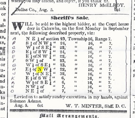
These two newspaper clippings were taken from
the 5 Aug 1837 edition of the weekly Southern Democrat of
Cahawba, Dallas Co., AL, Vol. 2, No. 6. The top clipping is from pg. 4,
col. 4. It lists Mr. Solomon Adams' four pieces of property in thirteen
parts (labeled by me for easier reference), all in Township
16, Range 7, as follows:
|
ID
|
Section Part
|
Sec.
No.
|
John M. Gwin Comments
|
| A |
NE 1/4 |
23 |
|
| B |
S 1/2 of NW 1/4 |
24 |
|
| C |
W 1/2 of SE 1/4 |
22 |
|
| D |
E 1/2 of SW 1/4 |
24 |
|
| E |
E 1/2 of NW 1/4 |
22 |
|
| F |
SW 1/4 |
23 |
|
| G |
W 1/2 of SE 1/4 |
23 |
|
| H |
E 1/2 of NW 1/4 |
22 |
Part H and part E are exactly the same in this
clipping. This is clearly an error, requiring deeper investigation to solve.
As I wanted to see where this property lay anyway, I therefore built a
grid (shown directly below the clippings) to represent Township 16,
Range 7--each smallest square representing ten acres--and logged the
data onto the grid. I then guessed that the missing 80 acres (part H) should
connect the other two 80-acre parts (parts E and C), meaning that part
H should have read E 1/2 of SOUTHwest 1/4, not NW. Sure enough, when I
looked at the three parts (E, C, and H) on the map of Dallas Co., a branch
of Bear Creek runs right through part C and where I guessed part H to be. |
| J |
W 1/2 of NE 1/4 |
32 |
|
| K |
E 1/2 of SW 1/4 |
6 |
|
| M |
W 1/2 of SE 1/4 |
6 |
|
| N |
NW 1/4 |
7 |
|
| O |
NE 1/4 |
7 |
|
. |
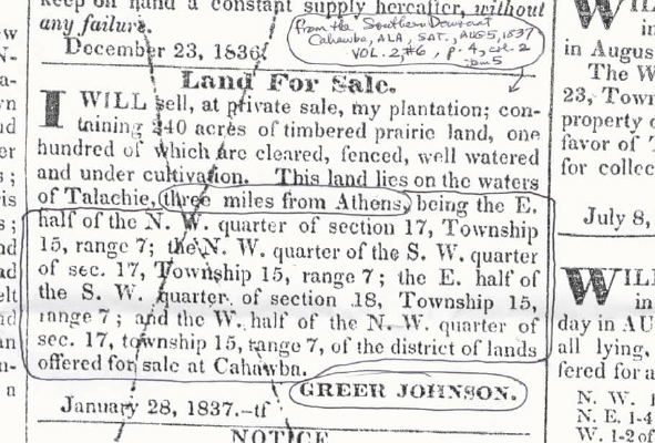 |
The second clipping is from pg. 4, col. 2. It
specifically mentions Mr. Greer Johnson's property's location as
being three miles from the Town of Athens,
bringing us closer to discovering the actual site of the town. I built
a township grid for the property (seen directly below the first grid).
It lists two (or is it one?--see my comment for part C) pieces of land
in four parts, all in Township 15, Range 7,
as follows:
|
ID
|
Section Part
|
Sec.
No.
|
John M. Gwin Comments
|
| A |
E 1/2 of NW 1/4 |
17 |
|
| B |
NW 1/4 of the SW 1/4 |
17 |
|
| C |
E 1/2 of the SW 1/4 |
18 |
There may be an error in this entry as well.
Looking at the second grid below, one can see that the 80-acre part C is
half a mile west of the bulk of the property. It seems to make more sense
to me that the property would have been connected (though not necessarily
so), and, given the earlier typo, it could be that this SHOULD
have read E 1/2 of the southEAST 1/4 (see
second grid below) |
| D |
W 1/2 of the NW 1/4 |
17 |
|
|